SEOSAT/INGENIO satellite begins its journey to Kourou
The Spanish optical Earth observation satellite SEOSAT/INGENIO will begin its journey from Torrejón air base in Madrid (Spain) to Kourou, for a launch on a Vega rocket. SEOSAT, acronym for Spanish Earth Observation Satellite, is a high-resolution optical satellite devoted to civil use, to be placed in orbit at an altitude of 670km with a launch scheduled on 18th November, 2020.
SEOSAT/INGENIO is a project of the Ministry of Science and Innovation within Spain’s national strategy, led by delegation by the CDTI (Centre for Industrial Technological Development), which also assumes the cost of the project. This satellite is an integral part of Spain’s National Satellite Earth Observation Program (PNOTS) together with PAZ, a SAR radar satellite in orbit since February 2018.
SEOSAT/INGENIO represents one of the largest projects undertaken by the Spanish industry - it has been built by an industrial consortium comprising 11 Spanish companies, with Airbus as prime contractor of the programme, SENER Aeroespacial as prime contractor of the optical instrument and Thales Alenia Space in Spain as supplier of all the electronics of the instrument and the satellite communication systems.
Thanks to the coordinated effort of all the companies involved, the construction of the satellite has been successfully completed, with the assembly of all the units in Madrid. SEOSAT/INGENIO will provide high resolution images to different civil, institutional and governmental users. Its main observation areas will be the Spanish territory, Europe, Latin America and North Africa, as well as the general areas defined by European users in the frame of Copernicus and GEOSS (Global Earth Observation System of Systems).
The information delivered by SEOSAT/INGENIO will have application in cartography, land management, coastal surveillance, water resources management, agricultural monitoring, precision agriculture, environmental control and crisis management (security and emergencies) in catastrophes.
The optical instrument
The satellite consists of a platform embarking a primary payload, a high-resolution, high-performance optical instrument with an image capacity of 2.5 million km2/day and up to 600 images per day. Led by SENER Aeroespacial and with electronics contribution of Thales Alenia Space, this instrument is designed to take terrestrial images in two channels - one panchromatic (PAN) and the other multispectral - which in turn is made up of four bands (blue, green, red and near infrared).
As the instrument prime contractor (see video), SENER Aeroespacial has been responsible for its conception, architectural design, manufacture, integration, alignment and verification - of the detailed optical, opto-mechanical and thermal design; of the integral management of the project, engineering coordination, quality control, and management of integration and tests activities; and the management of subcontractors and suppliers.
In addition, SENER Aeroespacial has been supported by Thales Alenia Space for the functional and optical quality validation of the instrument and the verification of the instrument qualification. Diego Rodríguez, Director of Space of SENER Aeroespacial, expressed the relevance of this mission for Spain and thanked the CDTI and Airbus for the trust placed in SENER Aeroespacial for the development of such a specific and vital technology for the mission.
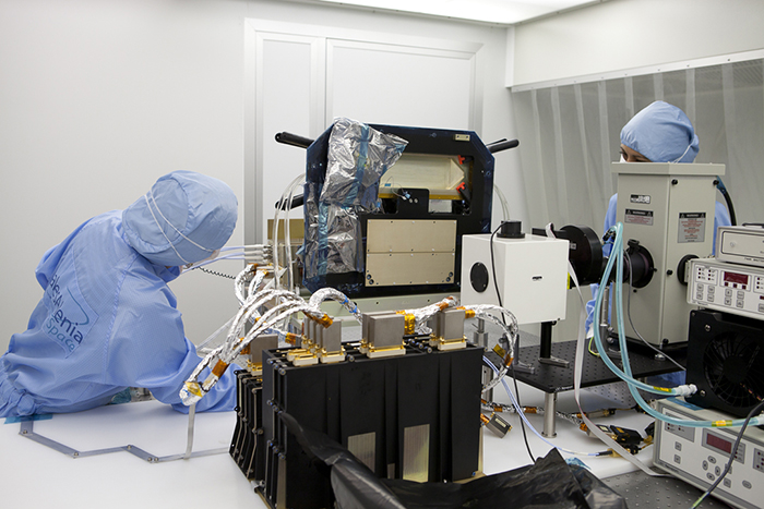
He added: “With SEOSAT/INGENIO, SENER Aeroespacial has developed the capacity to deal with this type of instrument, which is available to very few companies in Europe and the world.” The configuration consists of two identical cameras, complementarily aligned in order to acquire altogether the 55km trace needed to fulfil the mission objectives, working in sweep or pushbroom mode.
The primary payload provides a native image with ground pixel resolution of 2.5m in the panchromatic channel and 10m in the multispectral bands. The instrument achieves very high image quality and very good radiometric quality performances. It weighs 130kg and has an approximate volume of 1.5x1.5x1m.
Primary payload electronics
Thales Alenia Space in Spain drew on its expertise in the field of high-resolution optical technologies to design, manufacture, integrate, test and deliver all electronics for SEOSAT/INGENIO observation instrument. The payload electronics guarantee the correct operation of the cameras, as well as the power supply, data acquisition and transmission, and thermal control.
It plays a vital role in the success of this mission, since the equipment must be able to process the electronic signals that carry the image information at extremely high speed and without any degradation. Only advanced facilities like the Optical Detection Laboratory of Thales Alenia Space in Spain offer the environment and capabilities needed to assembly, integrate and test electronics equipment of this class.
Eduardo Bellido, CEO of Thales Alenia Space in Spain, continued: “We are proud to have contributed to the design of this satellite and to the instrument consecution, which is a milestone for Spain in the field of Earth observation. We would like to thank the CDTI and our industrial partners for calling on our proven expertise in communications systems and optical equipment, to provide new observation services to Spanish civil, institutional and government users. This success reinforces the positioning of our site in Madrid as a European centre of excellence in optical instruments and supports the expansion of our activities in the field of Earth Observation and science instruments.”
Once it enters into service, SEOSAT/INGENIO optical images will complement the radar images that Paz has provided since it started operations. In this way, Spain will have a dual satellite system, made up of an optical and a radar platform, whose data can be combined to offer higher resolution and enhanced information on the Earth’s surface.


