
Search results for "satellites"
Low-power hub supports multiple GNSS systems
Broadcom has announced the industry's first GNSS location hub that supports Galileo, a global satellite system being built by the European Union. The Broadcom BCM4774 simultaneously supports Galileo, GPS, GLONASS, SBAS, QZSS and BeiDou satellite systems.
GNSS module features 3D positioning, 100% coverage
The u-blox NEO-M8L all-in-one Global Navigation Satellite System (GNSS) module featuring continuous 3D positioning and 100 % coverage is available at Alpha Micro Components. Suited to all road vehicle and high-accuracy navigation applications, the module incorporates motion, direction and elevation sensors with a gyro and an accelerometer integrated into its GNSS platform u-blox M8.
EM simulation for space applications
Satellites provide a challenging environment for electromagnetic components and antennas. The limited available space has to be shared by multiple tightly-clustered systems that have to operate correctly in extreme thermal conditions. EM simulation plays a critical role in ensuring that mission-critical components work as intended once in orbit. This webinar will give an overview of how the range of simulation tools in CST STUDIO SUITE can be use...
Barometric sensors deliver an accuracy of ±0.12hPa
Bosch Sensortec has achieved cumulative shipments of 400m barometric sensors to enable development of mobile applications such as weather forecasting, altitude measurement, indoor navigation with floor level tracking, used for navigation, fitness and sports applications.
Sensor array facilitates highly accurate navigation
u-blox has introduced the NEO-M8L Automotive Dead Reckoning (ADR) module with integrated motion, direction and elevation sensors. The module integrates a gyroscope and an accelerometer with u‑blox’ leading GNSS platform M8, to achieve a high-performance indoor/outdoor positioning solution, available for all road vehicle and high-accuracy navigation applications.
Precision timing GNSS module targets cellular networks
A precision timing GNSS module that achieves high accuracy by disciplining a local oscillator or other clock source with timing signals received from satellite-hosted atomic clocks is available from Alpha Micro Components. The LEA-M8F module from u-blox is a compact, surface-mount unit which generates a precise 30.72 MHz reference clock crucial for synchronising industrial data and communication systems such as small, femto and macro-cell mobile ...
6-axis IMU is suitable for navigation & telematics
STMicroelectronics has announced what it claims to be the industry's smallest 6-axis IMU (Inertial Measurement Unit) qualified for automotive applications with low-noise and improved output resolution. The ASM330LXH targets on-board units for electronic road tolling, other vehicle telematics systems and in-dash car-navigation solutions that require accurate and reliable inertial sensors to optimise positioning and direction, even in the absence o...
FPGAs deliver precise time keeping in satellite watches
Citizen Watch are integrating Lattice Semiconductor's iCE40 FPGAs into it's Eco-Drive Satellite Wave F100 wristwatch. To enable the watch to display the correct time, the FPGA picks up the precise-time information from the input data of the GPS satellite signal receiver and generates control signals.
Waveform generator boosts wideband digital channel simulator
An Arbitrary Waveform Generator (ARB) has been added to IZT’s 3040 wideband digital channel simulator. The generator enables the simulator to emulate other traffic on the satellite transponder, signals in adjacent bands or interference scenarios. With the internal generator memory, the simulator now supports the generation of user-defined signals, for example using MATLAB, which increases its flexibility.
Cambridge Wireless announces inaugural CW TEC
Discussing the impact of emerging technologies on millimetre, microwave, UHF and VHF spectral value, the first CW TEC (CW Technology & Engineering Conference) has been announced by Cambridge Wireless. The event, which is scheduled to take place on 4th March 2015, will consider the impact that mobile, satellite, TV, IOT and wearable technology will have on the value of licensed and unlicensed spectrum.

Featured products
MAX17793
Analog Devices Inc.
3V to 80V, 3A, High-Efficiency, Synchronous Step-Down DC-DC Converter
| SKU: | MAX17793 |
|---|---|
| Stock: | 9316 |
| Cost: | $3.64 |
MAX22516
Analog Devices Inc.
IO-Link Data Link Controller with Transceiver and Integrated DC-DC
| SKU: | MAX22516 |
|---|---|
| Stock: | 8000 |
| Cost: | $5.42 |
Product Spotlight
102991834
BeagleBoard

Single Board Computer (SBC), BeagleY-AI
AM67A BeagleY-AI Jacinto 7 AR...
| SKU: | 2820-102991834-ND |
|---|---|
| Stock: | 208 |
| Cost: | $56.24 |
SC1110
Raspberry Pi
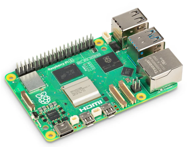
Raspberry Pi 5 2GB
The Raspberry Pi 5 2GB model represents a leap for...
| SKU: | 2648-SC1110-ND |
|---|---|
| Stock: | 0 |
| Cost: | $38.33 |
AKX00069
Arduino
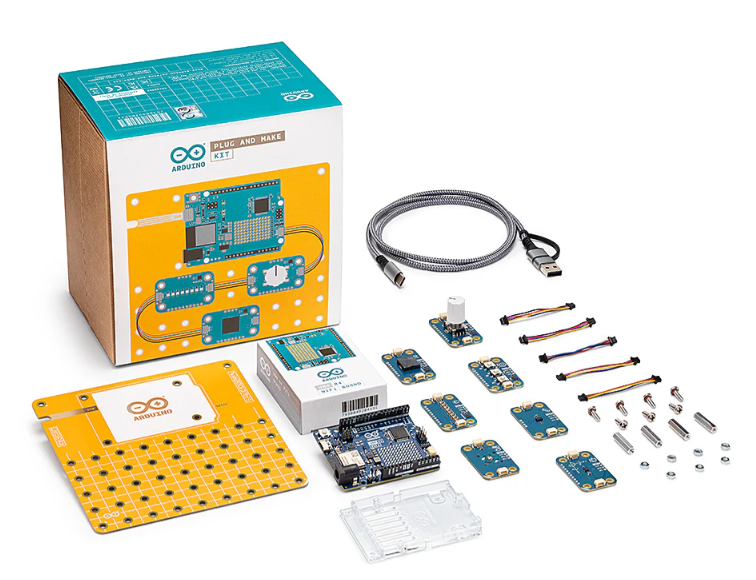
Arduino Plug and Make Kit
The Arduino Plug and Make Kit features the ...
| SKU: | |
|---|---|
| Stock: | 968 |
| Cost: | $66.97 |
300361-0011
Molex
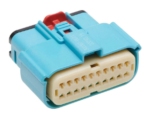
MX150 Mid-Voltage MatSealed Female Connector Assembly, Dual Row, 20 Circ...
| SKU: | |
|---|---|
| Stock: | 280 |
| Cost: | $2.51 |