Solar eclipse could help understand Earth’s energy system
It was midafternoon, but it was dark in an area in Boulder, Colorado on Aug. 3, 1998. A thick cloud appeared overhead and dimmed the land below for more than 30 minutes. Well-calibrated radiometers showed that there were very low levels of light reaching the ground, sufficiently low that researchers decided to simulate this interesting event with computer models. Now in 2017, inspired by the event in Boulder, NASA scientists will explore the moon’s eclipse of the sun to learn more about Earth’s energy system.
During the Aug. 21, 2017, total solar eclipse, scientists will use the Earth Polychromatic Imaging Camera (EPIC) on the Deep Space Climate Observatory satellite (DSCOVR), along with measurements taken from within the moon's shadow on the ground, to test a new model of Earth's energy budget.
On Aug. 21, 2017, scientists are looking to this year’s total solar eclipse passing across America to improve our modelling capabilities of Earth’s energy. Guoyong Wen, a NASA scientist working for Morgan State University in Baltimore, is leading a team to gather data from the ground and satellites before, during and after the eclipse so they can simulate this year’s eclipse using an advanced computer model, called a 3D radiative transfer model.
If successful, Wen and his team will help develop new calculations that improve our estimates of the amount of solar energy reaching the ground, and our understanding of one of the key players in regulating Earth’s energy system, clouds.
Earth’s energy system is in a constant dance to maintain a balance between incoming radiation from the sun and outgoing radiation from Earth to space, which scientists call the Earth’s energy budget. The role of clouds, both thick and thin, is important in their effect on energy balance.
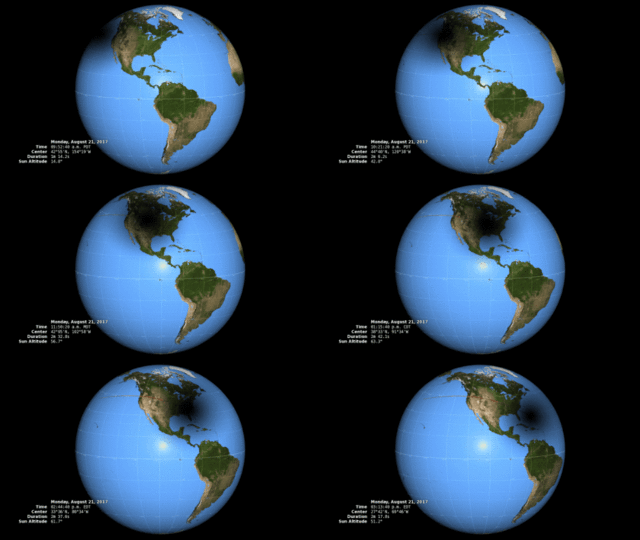
Like a giant cloud, the moon during the 2017 total solar eclipse will cast a large shadow across a swath of the United States. Wen and his team already know the dimensions and light-blocking properties of the moon, but will use ground and space instruments to learn how this large shadow affects the amount of sunlight reaching Earth’s surface, especially around the edges of the shadow.
“This is the first time we’re able to use measurements from the ground and from space to simulate the moon’s shadow going across the face of Earth in the United States and calculating energy reaching the Earth,” said Wen.
Scientists have made extensive atmospheric measurements during eclipses before, but this is the first opportunity to collect coordinated data from the ground and from a spacecraft that observes the entire sunlit Earth during an eclipse, thanks to the National Oceanic and Atmospheric Administration’s Deep Space Climate Observatory launched (DSCOVR) in February 2015.
Even though the moon blocking the sun during a solar eclipse and clouds blocking sunlight to Earth’s surface are two different phenomena, both require similar mathematical calculations to accurately understand their effects.
Wen anticipates this experiment will help improve the current model calculations and our knowledge of clouds, specifically thicker, low altitude clouds that may cover about 30% of the planet at any given time.

DSCOVR's Earth Polychromatic Imaging Camera (EPIC) will capture images similar to this one from the Lagrange 1 point, about a million miles away from Earth.
Credits: NASA/Katy Mersmann
In this experiment, Wen and his team will simulate the total solar eclipse in a 3D radiative transfer model, which helps scientists understand how energy is propagated on Earth. Currently, models tend to depict clouds in one dimension. In many cases, these one-dimensional calculations can create useful science models for understanding the atmosphere.
Sometimes though, a 3D calculation is needed to provide more accurate results. The big difference is that 3D clouds reflect or scatter solar energy in many directions, from the top and bottom, and also out of the sides of clouds. This 3D behavior results in different amounts of energy reaching the ground than a one-dimensional model could predict.
“We’re testing the ability to do a certain kind of complex calculation, a test of a 3D mathematical technique, to see if this is an improvement over the previous technique,” said Jay Herman, scientist at NASA’s Goddard Space Flight Center in Greenbelt, Maryland, and co-investigator of the project.
“If this is successful, then we will have a better tool to implement in climate models and can use it to answer questions and the Earth’s energy budget and climate.”
For the upcoming eclipse, Wen and his team members will be stationed in Casper, Wyoming, and Columbia, Missouri to gather information on the amount of energy being transmitted to and from Earth before, during and right after the eclipse with several ground instruments.
A ground-based, NASA-developed Pandora Spectrometer Instrument will provide information on how much of any given wavelength of light is present, and a pyranometer will measure total solar energy from all directions coming down toward the surface.
Immediately before and after the eclipse scientists will measure other information such as the amount of absorbing trace gases in the atmosphere, such as ozone, nitrogen dioxide and small aerosol particles to also use in the 3D model.
Meanwhile in space, NASA’s Earth Polychromatic Imaging Camera, or EPIC, instrument aboard the DSCOVR spacecraft, will observe the light leaving Earth and allow scientists to estimate of the amount of light reaching the earth’s surface.
Additionally, NASA’s two MODIS satellite instruments, aboard the agency’s Terra and Aqua satellites, launched in 1999 and 2002, respectively, will provide observations of atmospheric and surface conditions at times before and after the eclipse. The scientists will then combine ground measurements with those observed by the spacecraft.
This experiment complements NASA’s decades-long commitment to observing and understanding contributions to Earth’s energy budget. For more than 30 years, NASA has measured and calculated the amount of solar energy hitting the top of our atmosphere, the amount of the sun’s energy reflected back to space and how much thermal energy is emitted by our planet to space.
These measurements have been possible thanks to instruments and missions such as ACRIMSAT and SOLSTICE (launched in 1991), and SORCE, launched in 2003 as well as the series of CERES instruments flown aboard Terra, Aqua, and Suomi-NPP (launched in 2011).
This fall, NASA will continue to monitor the sun-Earth relationship by launching the Total and Spectral Solar Irradiance Sensor-1, or TSIS-1, to the International Space Station and the sixth Clouds and the Earth’s Radiant Energy System CERES instrument, CERES FM6, to orbit later this year. Five CERES instruments are currently on orbit aboard three satellites.


